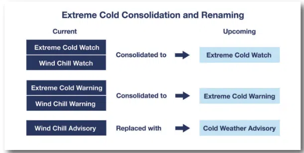
It’s not necessarily a forecast, but National Weather Service meteorologists are changing the language they’ll be using if and when extreme cold arrives this winter. The term “wind chill” won’t be used as much anymore, but instead the watches and warnings will use the terms “Extreme Cold” or “Cold Weather” depending on newly-established thresholds, and those metrics also depend on your location.
Windchill still plays a role, so when that wind chill is likely to reach minus 30 degrees or lower within a day or so, an “Extreme Cold Watch” will be issued, and that changes to a warning when forecasts are more certain. Wind chills of between 20 and 30 below will now generate a “Cold Weather Advisory”.
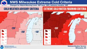
Roughly the northwest half of Wisconsin will have different metrics that are five degrees colder than the trigger points in the southeastern half of the state, and that’s based upon the impacts likely to affect people and their activities in those differing regions.
NWS Graphics Show Area Differences in Cold Weather Warnings
For what it’s worth, the National Weather Service in Milwaukee says their office has averaged about 5 wind chill advisories per season, and one such warning every five years, but with trigger points of around 5 degrees warmer than before, that could increase to a warning every other year or so. Also for what it’s worth, the October through December forecast gives equal chances of either above or below normal temperatures.


Comments