The National Weather Service is convinced that unlike the last few years, drought will not be a problem in Sheboygan County this time around. But instead, excess rainfall has become a problem for farmers, and expected storms this weekend won’t help.
NOAA’s Climate Prediction Center released its latest seasonal drought outlook concerning July through September, with no drought in the forecast. Instead, an extra 4.12 inches of rain made for the 2nd wettest May on record, while the year so far is 5.19 inches above normal, making 2024 the 6th wettest year to date going back 130 years.
The US Department of Agriculture said that topsoil moisture is adequate in 60 percent of the state, with 40 percent reporting a surplus. Last week, the USDA said that 1 percent of both Corn and Soybean fields were in “very poor” shape, and only 16-17 percent were in excellent condition.

Potential Heavy Rain Predictions for Today & Saturday Threaten Flash Floods to our West
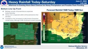
Meanwhile, more heavy rains could result from several rounds of thunderstorms beginning this afternoon. The first is expected between 3 and 9 p.m. today, and the second round will likely occur between 2 and 11 p.m. Saturday. Between the two, Sheboygan County could pick up between three-quarters and an inch-and-three-quarters of rain. Even heavier potential rains on already-soaked grounds have necessitated a flash flood watch for Washington and Fond du Lac Counties from 2 this afternoon through Saturday evening.


Comments