As much as perfect weather on a busy summer weekend would be…perfect…it will still be wise to pay attention to several significant factors affecting weather over the next few days.
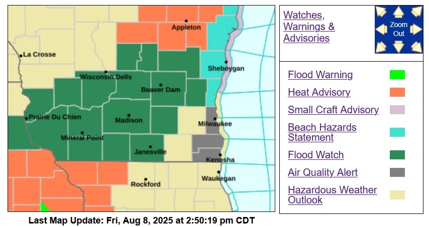
A Flood Watch that will be in effect from Saturday afternoon through Monday morning was issued by the National Weather Service early Friday afternoon. It’s anticipated that multiple rounds of thunderstorms and heavy rain could occur during that period, resulting in excessive runoff into rivers, creeks and streams, flooding their banks and other low-lying areas. Inundation can take place rapidly in a flash flood, however it’s also a possibility that slower rainfall in excess of 2-1/2 inches during that extended period could result in ponding.
While hot, humid weather is predicted to remain during the weekend, a cooling dip into Lake Michigan is not recommended on Saturday from noon until 10 PM due to life-threatening waves of 3-5 feet, producing dangerous currents. Such waves can also, no doubt, amp up the difficulty for the Mercury Racing Midwest Challenge racers offshore of Sheboygan. The Beach Hazard Statement encompasses Sheboygan and Ozaukee Counties.
Meanwhile, ground-level ozone concentrations have reached levels that are unhealthy for sensitive groups, and there’s a chance the level could reach levels unhealthy for all groups. An Air Quality Advisory is in effect for lakeshore counties from Sheboygan southward to Racine until 11 PM tonight.


Comments