Forecasters are expressing more confidence in their predictions of higher snowfall totals in Sheboygan County as well as northern Ozaukee County. Rates of snowfall which began around 9 a.m. had been between a half and three-quarters of an inch per hour, and those rates could increase to around an inch per hour tonight as Lake Michigan begins contributing its moisture to the system.
As of 3 p.m. Thursday, nearly an inch accumulation had been reported at the Sheboygan County Airport, and the National Weather Service is advising of a general addition of between 3 to 6 inches across the region. However, those amounts increase to between 5 and 9 inches in Sheboygan County.
As our snowfall is forecast to continue well into Friday, the Winter Weather Advisory now in effect will continue until noon tomorrow, while counties from Fond du Lac to Jefferson and points west will end theirs at 6 a.m.

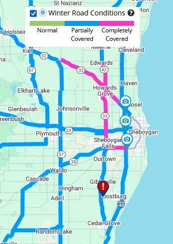
This Capture from Wisconsin 511 Shows Road Conditions at Around 3 PM Thursday, and a Crash on Highway 32 Near Oostburg
It goes without saying that traffic will be impacted, as demonstrated by a crash that closed the northbound lane of Highway 32 south of Sheboygan County Highway “A” around 1 p.m. The State Patrol did not report on any possible injuries. Slippery conditions will be most impactful both during this evening’s, and tomorrow morning’s commutes.

NWS Graphic
The Alberta Clipper system at the core of the storm will be exiting early tomorrow, taking its snows along with it by noon, ending the advisory. In its wake, skies will become mostly sunny with temperatures in the 20s, making for favorable conditions to clear away what could add up to between 6 and 10 inches of snow that should stick around to provide a White Christmas.


Comments